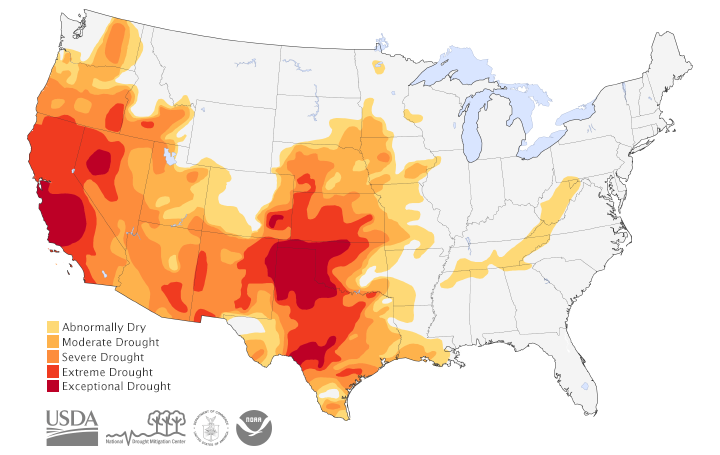
As of May 6, 2014, half of the United States was experiencing some level of drought. Nearly 15 percent of the nation was gripped by extreme to exceptional drought. For the Plains and the Southwest, it's a pattern that has been persistent for much of the past several years.
The map above was developed by the U.S. National Drought Monitor, a partnership of U.S. Department of Agriculture, the National Oceanic and Atmospheric Administration, and the University of Nebraska-Lincoln. It depicts areas of drought in progressive shades of orange to red. It is based on measurements of climate, soil, and water conditions from more than 350 federal, state, and local observers around the country. (NASA also provides experimental measurements and models to the drought monitoring effort.)
...Drought has had a serious impact on fruit and vegetable agriculture in California, and news reports sounded the alarm for grains and livestock in the Plains and South Central West. At least 54 percent of the nation's wheat crop is affected by some level of drought, as is 30 percent of corn, and 48 percent of cattle.
References and Related Reading
- Associated Press, via The Brownsville Herald (2014, May 12) Arizona town near Grand Canyon runs low on water. Accessed May 12, 2014.
- Farmers Weekly (2014, May 12) U.S. drought could halve wheat harvest in Oklahoma. Accessed May 12, 2014.
- U.S. Drought Portal (2014, May 6) Weekly Drought Update. Accessed May 12, 2014.
- U.S. National Drought Monitor (2014, May 8) National Drought Summary for May 6, 2014. Accessed May 12, 2014.
- Weather Underground (2014, May 7) Weather Extremes: Record Heat, Drought Continues in Southern Plains. Accessed May 12, 2014.
Map courtesy of the U.S. Drought Monitor. Caption by Mike Carlowicz.
