Nov 8, 2007

Producing geothermal power from oil and gas wells in the Gulf of Mexico is also being considered.

http://www.renewableenergyaccess.com/rea/news/ate/story?id=49161

U.S. Geothermal Resource Map

The geothermal resources map of the United States below shows the estimated subterranean temperatures at a depth of 6 kilometers. To determine the Earth's internal temperature at any depth below the capabilities of normal well drilling, multiple data sets are synthesized. The data used for this figure are: thermal conductivity, thickness of sedimentary rock, geothermal gradient, heat flow, and surface temperature.
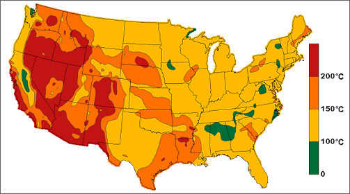
Geothermal Resource Map of the United States showing the continental United States with estimated subterranean temperatures of 200C plus shown in red, estimated subterranean temperatures of 150°C to 200°C shown in orange, estimated subterranean temperatures of 100°C to 150°C shown in yellow, and estimated subterranean temperatures of 0° to 100°C shown in green. Red areas are located primarily in the western states including Washington, Oregon, California, Idaho, Nevada, Montana, Colorado, Arizona, and New Mexico. Most of the map is colored yellow.

Also see geothermal resource maps.